Turning Storm Data into Health Intelligence
Real-Time Health Risk Intelligence for Every Storm, Everywhere
HERA (Health Emergency Risk Analytics) is a next-generation, AI-driven system that
continuously monitors hurricane and tropical storm activity across the Americas and beyond —
turning live weather and environmental data into actionable health intelligence.
Developed with U.S. government support and international partners, HERA bridges the gap
between meteorological data and public health action, helping nations predict, prepare for, and
protect against storm-related health crises.
How HERA Works
Every minute, HERA integrates:
- Live data from the U.S. National Hurricane Center and other global sources
- Population vulnerability indicators
- Healthcare infrastructure and accessibility
- Social and environmental determinants of health
The result:
Real-time insights into who is at risk, where care will be needed most, and how to direct
resources effectively - before, during, and after the storm.
A System Built for the Entire Hemisphere
From the Caribbean to Central and South America to the U.S. Gulf and Atlantic coasts, HERA
operates 24/7, automatically updating as storms form, strengthen, and move.
Health systems, emergency agencies, and humanitarian organizations use HERA to:
- Prioritize vulnerable populations for evacuation and aid
- Identify regions at risk of healthcare disruption
- Inform response and recovery planning
- Support international coordination across borders
Powered by Anna — Generative AI Orchestration for Health Resilience
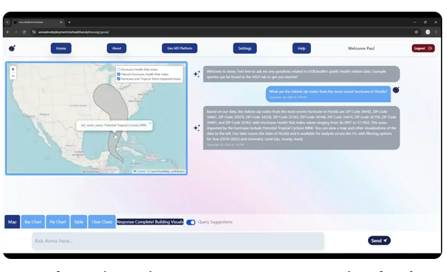
HERA is orchestrated through Anna, our generative AI platform for health analytics. Users can simply ask questions like:
'Which communities are at the highest health risk from this storm?'
'How will hospital access be affected if this system makes landfall?'
Anna translates complex geospatial data into understandable insights — instantly.
From Prediction to Protection
HERA turns storm path forecasts into forecasted impact — on people, communities, and
health systems.
By merging geospatial intelligence with health data, it empowers decision-makers to act before
lives are at risk.
Partner With Us
HERA was developed with support from U.S. federal agencies and international collaborators,
and is available for immediate deployment across the Western Hemisphere.
We're seeking partnerships with:
- National governments & health ministries
- Regional disaster management agencies (e.g., PAHO, CARPHA, ODPEM, etc.)
- Donors and innovation funds advancing global health resilience