Poseidon Plastic Tracking System
Protecting oceans. Safeguarding lives.
Poseidon turns satellite imagery, geospatial analytics, and health-focused intelligence into actionable insight on ocean plastics, human exposure, and community risk.
This page brings together the core Poseidon dashboards and supporting context to help users explore coverage, plastic presence, and the Plastic Bioaccumulation Health Risk Index.
Mission
Turning plastic intelligence into public health action
Poseidon helps identify where plastics may be accumulating, which populations may face elevated exposure risk, and where action can have the greatest protective effect.
The goal is not only to map the problem, but to support better environmental and health decisions.
Toxins are increasing across ecosystems and the food chain in part because of plastic pollution in oceans and waterways. Concern has grown that this plastic may enter fish and other sea life, contributing to potentially dangerous levels of bioaccumulated exposure in humans who rely on that food supply.
While the science is still evolving, emerging research suggests plastics, microplastics, and their associated toxins may have important health consequences. To help address that, Geo Orchestration AI developed the Poseidon Plastic Tracking System to identify the presence and quantity of plastics in oceans near populations that may face elevated short- and long-term risk.
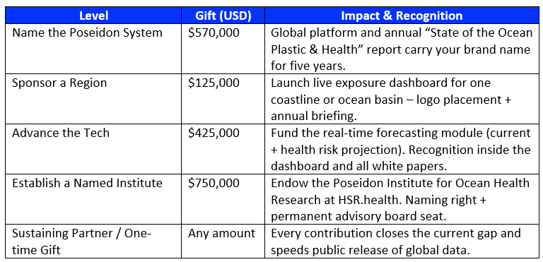
How you can help
Expand public access and global coverage
Every dollar accelerates free public access to Poseidon's exposure dashboard, API, and research archive — turning data into action for at-risk communities and our oceans.
Funding Progress
Funding Snapshot
- Total project need: $570,000
- Already raised: $325,179
- Remaining gap: $244,821
This is not a one-time fix. It is a sustainable, continuously updated system that gives the world the insight it needs to act before it is too late.
Poseidon is real. It is working. And with the right support, it is ready to scale globally.
Coverage
Is my ocean area covered?
To make global ocean analysis operationally manageable, Geo Orchestration AI divided the world's oceans into 22 regions. Poseidon is steadily progressing through each region toward global coverage.
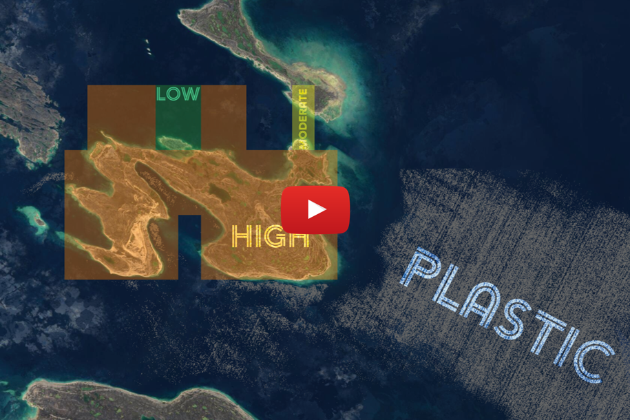
Detection
Plastic Presence Analysis
Within each region, Sentinel-2 imagery is retrieved and run through a sea-surface plastic detection algorithm. The map below shows analyzed scene footprints along with the percent of each scene detected as plastic.
U.S. Coastlines
US Beaches Plastic Presence Analysis
Poseidon also analyzes plastic presence within a 120-mile buffer of U.S. beaches, helping surface coastal risk patterns in areas closely tied to human activity and exposure.
Health Risk
Plastic Bioaccumulation Health Risk Index
Poseidon's Plastic Bioaccumulation Health Risk Index is based on the health and social factors that influence vulnerability to adverse health outcomes from plastic bioaccumulation, including age, chronic health conditions, and pregnancy or breastfeeding status.
Deeper Dive
Plastic Bioaccumulation Health Risk Index Dashboard
In addition to the map, the dashboard below provides a deeper view into the contributing social factors along with supporting charts and tables.
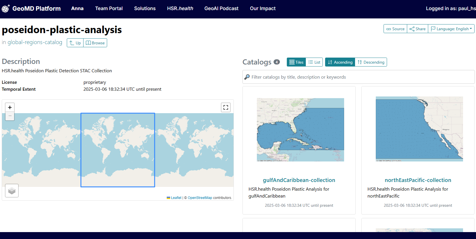
Open Data for Global Action
Poseidon STAC Catalog
To increase accessibility and transparency, Poseidon includes a SpatioTemporal Asset Catalog (STAC) that enables researchers and policymakers to explore Sentinel-2 imagery, support intervention strategies, and collaborate more effectively on ocean plastic tracking.
- Explore satellite imagery related to plastic pollution
- Support data-driven intervention strategies
- Improve global collaboration and transparency
In the News
More on how Poseidon is fighting ocean plastic pollution
- Group on Earth Observations (GEO) blog coverage
- GeoAI Podcast episode featuring NOAA, USGS, and NRCan
- Engineering report, recent blogs, and pilot webinar resources
Partners
Supporting organizations
Start Mapping What Matters
Support or connect with our team
Help expand Poseidon's reach or contact us to discuss collaboration, sponsorship, or deployment.